Wednesday, August 13, 2014

THOUGHTS ON 100° DAYS IN THE BRAZOS VALLEY.....

It's funny when you think about it. We came up with a contest at KAGS-HD where if Easterwood Airport hits 100° for the first time, I will come to your house, and mow your lawn, along with additional various prizes. However, we have passed the month of June, July, and most of August without getting close. The highest temperature reported at Easterwood this year is 97° this year. That's it! Just for your information, the last time Easterwood failed to hit 100° or higher in an entire year, was back in 2004. Yes, it has happened before. We do average 10 days with 100° air, so its bound to happen....we think.

There have been several locations around Bryan and College Station that have reached 100° a handful of times, but many inhibiting factors have lead to our "cooler" than average Summer thus far. One big element has been timely rain to lower temperatures significantly. In the month of July, over 6 inches of rain fell. For July, that does not happen often.

Additionally, our wind direction have been primarily from two different origins. Either from the north, or more frequently, the south.


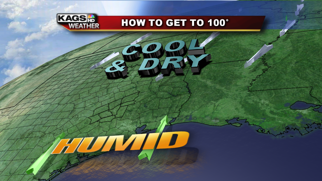
A north wind will not only suppress the humidity, but also take the temperatures down a notch or two during the Summer. On the flip side, a south wind allows the flood gates to open from the Gulf of Mexico and pumping up our atmosphere with much more moisture. Additionally moisture (or humidity) in the air makes it tough for the air to heat up quickly and intensely. Therefore, the more humidity in the air, the harder it is for extremely high temperatures.

There are many other atmopsheric dynamic that can help contribute to a 100°, but one of the more reliable ways is a different wind direction. A southwest wind.


I cannot remember a day this Summer, where a broad southwest wind was pushing into the Brazos Valley. The reason why this is crucial, is because this wind direction leads to drier, and much hotter air. From the southwest, wind slopes down the tall mountains over Mexico and blows into Texas. As air sinks, it expands, dries, and heats quickly. For the entire Brazos Valley to have the best chance for widespread 100°+ air, a southwest wind needs to be in place. However, I do see this happening over the next 7-10 days. Yes, it will still be hot, but not 100°.  

“Take a look up once in a while; you never know what you’ll miss.”

For more news and weather you can log onto: www.facebook.com/plushnickweather or www.facebook.com/KAGSTV. You can also check out our twitter feeds: @KAGSweather and @KAGSnews. Furthermore, you can download our new weather app. Search: KAGS Weather, in the Apple App Store or Google Play for Android.

Tuesday, June 24, 2014

HEAT: Play It Safe

Picture: inhabitat.com

It’s that time of the year again when we roll out the grills, sit by the pool, take extra long vacations, and stand outside in the heat for extended periods of time. Sounds fun, right? Yes, it does, but if you don’t play by the rules and keep heat safety a top priority, you could fall victim to one of the most underrated weather elements that can cause severe bodily injury.

In fact, heat is the top weather related killer in the United States. Taking the averages of weather related deaths between 2003-2013 across the county, heat is at the top of the list. On average, there have been 117 heat related deaths on a yearly basis. Second on the list is a tie with tornadoes and hurricanes at 107, and floods comes in third with 76 deaths per year. The reason why heat is primary killer is because it affects more Americans than any other weather phenomenon.

Hot air can do a number on your body and it does not take much time to be out in the heat to feel its effects. If you are suffering from heat related illnesses, you will likely experience dizziness, muscle cramps, weak pulse, overall weakness, nausea, and even fainting. If you, or someone you know illustrates these symptoms, make sure to move to a cool place, apply a wet cloth to cool down, sit in front of a fan, and sip on cool water.

Not only can the actual heat cause problems, but the sun angle is at its peak during this time of the year. Not only are the daylight hours extended, but the sun’s intensity is another reason to keep it safe this summer season. This time of the year, it takes less than 10 minutes of unprotected exposure to cause sunburn. Sunburns are not fun at all, and if you are severely affected, you might feel a flu-like fever, nausea, headaches, chills, weakness, and even blisters. Apply SPF 30+ sunscreen all over your body as often as you can, at least every 60 minutes, wear a hat, lose light colored clothing, and slap on a pair of sun glasses to prevent as much as the sun’s harmful rays.

Overall, just have fun out there this summer, but make sure safety is always on your mind. If you take care of these simple things, and stay hydrated too, you will have an amazing summer season.


“Take a look up once in a while; you never know what you’ll miss.”

For more news and weather you can log onto: www.facebook.com/plushnickweather or www.facebook.com/KAGSTV. You can also check out our twitter feeds: @KAGSweather and @KAGSnews. Furthermore, you can download our new weather app. Search: KAGS Weather, in the Apple App Store or Google Play for Android.

Tuesday, June 17, 2014

Twin Tornadoes, Rare, But Has Happened Before

Before going into detail about the potential of how a twin tornado occurred yesterday in Pilger, Nebraska, know that this is something very rare, but has happened before. Additionally, there are many more storm chasers now than ever before and we can capture more information, in vast volumes, plus it spreads all over the internet, as well as media at rapid rates. Furthermore, meteorology is a growing science where we keep learning more over time. We know a lot, but there is much more research ongoing.

Anyway, below is one of the pictures of the twin tornadoes taken by storm chasing expert, Reed Timmer. 


This picture can say well more than a thousand words. To have two tornadoes that are extremely violet, right next to each other, is very unusual. Several theories do exist, but again, no straight up answer at this time.

For this type of situation to happen there could have been two different updrafts within one or two separate super cell thunderstorms. On the other hand, for two supercells or tow updrafts to be adjacent to one another is atypical. What tends to happen is one supercell takes over while the second collapses and transfers its energy to the other. In the picture above, it appears that the two updrafts, or supercells balance each other and create an environment where two strong tornadoes can exists side by side. Overtime, the two eventually linked together and created one larger tornado.

This goes into the next potential theory, a multi-vortex scenario. In most occurrences, there is only one vortex (rapidly rotating spin) per tornado. However, there are some single tornadoes that generate multiple vortexes, but tend to be very hard to see. Here, we might have and extreme case of multiple vortexes.

These are just a couple of theories, but more research will help the science of meteorology come closer to a real solution.

This has happened before, such as back in 1965 on Palm Sunday in Elkhart, Indiana. Paul Huffman snapped this picture of twin tornadoes during that outbreak below.


Another such occurrence happened in Hesston, Kansas in 1990. I was not able to find a picture of this event, but has been documented.

It's always saddening to see how destructive tornadoes can be, and what occurred in the Nation's Heartland last night was devastating. As more research continues on severe weather, forecasting steadily becomes more accurate.

In the meantime, if there is a Tornado Warning for your area, please make sure to respect Mother Nature's fury and take every precaution possible to protect yourself from the elements.

"Take a look up once in a while; you never know what you’ll miss."

For more news and weather you can log onto: www.facebook.com/plushnickweather or www.facebook.com/KAGSTV. You can also check out our twitter feeds: @KAGSweather and @KAGSnews. Furthermore, you can download our new weather app. Search: KAGS Weather, in the Apple App Store or Google Play for Android.

Wednesday, June 4, 2014

Minor Activity In The Tropics

Typically the beginning of the Hurricane season in the Atlantic Basin is quite slow, but by August and September, things really begin to heat up. Below is a chart laying out the percentages (%) of the amount of storms that typically generate. The greater the percentage, the greater amount of storms in that given month.


Easy to see that June and July are relatively quite compared to August, September, and even October. This is because the water temperatures reaches its peak and upper level winds favor development and strengthening of tropical systems during this time.

Also, if you are curious, the list of Tropical Storm/Hurricane names begin with Arthur and end with Wilfred this year.


Aside from the typical tropical jargon and names, there is a disturbance that bares watching in the southern Gulf of Mexico and Bay of Campeche.


The National Hurricane Center (NHC) is going to monitor this swirl for further development. At this time, there is only a 20% chance that over the next 5 days, this area will turn into an organized tropical system. Its early in the season and the right ingredients are not in place for a major storm to take shape.

Even the computer models are confused on an exact forecast due to the ragged nature of this system and its disorganization.


Sure, one model brings this into Texas, but that will likely NOT happen. Nonetheless, I will watch this and other tropical cyclones that develop this season for you.

In the meantime, we can sit back and relax as our weather should be repetitive with warmth and tranquility.

"Take a look up once in a while; you never know what you’ll miss."

For more news and weather you can log onto: www.facebook.com/plushnickweather or www.facebook.com/KAGSTV. You can also check out our twitter feeds: @KAGSweather and @KAGSnews. Furthermore, you can download our new weather app. Search: KAGS Weather, in the Apple App Store or Google Play for Android.